|
In grateful
appreciation to:
Bob Grigg
Curator:
Colebrook Historical
Society
Municipal Historian:
Town of Colebrook,
County of Litchfield,
State of Connecticut, USA
The Metropolitan District
Commission... , with the thought toward providing water resources for the
future, in the 1930’s, began buying up available land in the watershed area
of the West Branch of the Farmington River.

|
The Metropolitan District Commission, a
 company
providing water and other services to the Greater Hartford Connecticut area,
with the thought toward providing water resources for the future, in the
1930’s, began buying up available land in the watershed area of the West
Branch of the Farmington River. Essentially, this meant the village of
Colebrook River would be drowned by the waters behind a dam constructed at a
narrow gorge known as “The Hogback”, just east of the Colebrook town line in
the town of Hartland. Here is a chronology of the events leading up to the
elimination of Colebrook’s eastern population center, and the creation of
the body of water known today as Colebrook River Lake: company
providing water and other services to the Greater Hartford Connecticut area,
with the thought toward providing water resources for the future, in the
1930’s, began buying up available land in the watershed area of the West
Branch of the Farmington River. Essentially, this meant the village of
Colebrook River would be drowned by the waters behind a dam constructed at a
narrow gorge known as “The Hogback”, just east of the Colebrook town line in
the town of Hartland. Here is a chronology of the events leading up to the
elimination of Colebrook’s eastern population center, and the creation of
the body of water known today as Colebrook River Lake:
June 11, 1945
The M. D. C. now owns 75% of Colebrook River land.
October 13, 1945
The M. D. C. continues clearing land at
Hogback.
Sept. 26, 1947
A number of prospective buyers were in
Colebrook River looking over houses and other buildings there that the M. D.
C. now owns and which are being offered for sale. Purchasers demolish and
carry away the lumber and other building materials salvaged. It was
understood that the M. D. C. now owns 80% of the valley.
January 21, 1949
The Methodist Church and its property was sold
with the right to occupy it for 3 years until Jan. 13, 1952.
May 24, 1949
Despite an aggressive fight against the
Hogback “water grab” bill by many throughout Litchfield County, it passed
the House of Representatives by a vote of 117 to 84.
August 31, 1949
The M. D. C. plans to spend $10,000,000 for
the Hogback Dam. The main expenditures as proposed by their finance board
are:
Dam & appurtenances………………. $4,400,000
Clearing land………….…………….. $385,000
Relocation of highways & cemeteries… $605,000
Constructing tunnel to Barkhamsted Res. $2,
750,000
(This was never done.)
Interest (on money) during construction
$355,000
Unallocated expenses…………………. $705,000
 William Wurts, district manager, urged that
construction for the reservoir be started in 1950. The M. D. C. hoped to
have the reservoir completed by 1955 to fulfill the secret contract
with riparian rights owners such as the Collins Company, Stanley Works, and
others. William Wurts, district manager, urged that
construction for the reservoir be started in 1950. The M. D. C. hoped to
have the reservoir completed by 1955 to fulfill the secret contract
with riparian rights owners such as the Collins Company, Stanley Works, and
others.
4,411 acres are already acquired with a
projected 575 additional proposed. Capacity of the completed dam will be
6,500,000,000 gallons. It will back up 4 miles, be 116 feet deep maximum,
and cover 550 acres. Besides purchasing additional land that will be filled
with excess water during flood stages, the M. D. C. will rebuild about 3½
miles of State Highway along the west shore of the reservoir.
July 29, 1953
Residents of Beech Hill were shaken when
blasting for the construction of the re-aligned Conn. Rt. 8 caused damage
such as cracked ceilings and walls as well as disruption of water flow.
(Springs and wells were affected.) An arrest was made.
July 31, 1953
The M. D. C. is preparing to remove existing
cemeteries in Colebrook River to a new location now under construction on
Eno Hill. Persons interested in arranging for the removal of the remains of
relatives to locations other than the new cemetery are requested to
communicate with the Chief Engineer of the M. D. C.
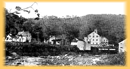
The Cotton Mills, Colebrook River, Conn.
February 18, 1954
The M. D. C. has recently acquired the final
piece of property needed for the construction of the Hogback Dam. This was
property owned by Austin and Hazel McCormack of N. Y. C. It consisted of an
18-room dwelling, large barn and 64 acres located just north of the church
property on Route 8. The Commission now owns 4,106 acres. The next-to-last
property sold was Eugene Bourquin’s 89 acres, sold on November 15, 1953. All
bodies from the old cemeteries have been moved. A number of the graves were
from former inhabitants of Tolland Mass.
1955
The M. D. C., barely finished with the construction of the Goodwin Dam at
Hogback, began planning for the construction of the Colebrook River Dam. In
1965, the Army Corps of Engineers took over the project, explaining that the
valley and the towns below needed adequate flood protection. They cited the
damage caused by the 1938 and 1955 floods. They constructed the
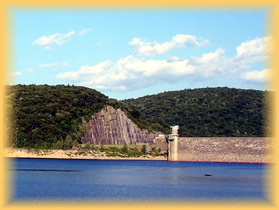 1969
Colebrook River Dam, dedicated on June 27, 1969. The total cost, including 7
miles of Rt. 8 in Conn. and Mass. was $14,400,000. 1969
Colebrook River Dam, dedicated on June 27, 1969. The total cost, including 7
miles of Rt. 8 in Conn. and Mass. was $14,400,000.
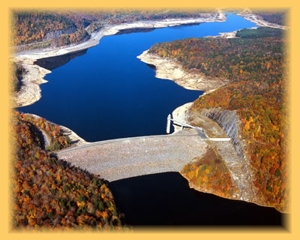
The maximum amount of water stored behind this
dam is16 billion gallons, although the normal amount is 10 billion, the rest
being an emergency reserve in case of flooding.
When the pool (as they call the body of water
behind the dam) is at its maximum, (the height of the spillway on the east
end of the dam) it stands at 761 feet above sea level. This gives it a water
surface area of 1,210 acres, extending 6 miles upstream and into
Massachusetts. This is about where present day Route 8 crosses south of New Boston. The depth of the
water would then be about 200 feet. The dam that can be seen from Rt. 8 is
1,300 feet long with a maximum height above the streambed of 223 feet. An
earthen dike, 1,240 feet long with the access road on top, stretches from
Rt. 8 to the opposite hillside. A 243-foot high control tower houses 3
service gates and 3 emergency gates, all hydraulically operated. The
controlled reservoir outlet is through a 10-foot diameter tunnel, and is 778
feet long. The drainage area served by this dam is 118 square miles. present day Route 8 crosses south of New Boston. The depth of the
water would then be about 200 feet. The dam that can be seen from Rt. 8 is
1,300 feet long with a maximum height above the streambed of 223 feet. An
earthen dike, 1,240 feet long with the access road on top, stretches from
Rt. 8 to the opposite hillside. A 243-foot high control tower houses 3
service gates and 3 emergency gates, all hydraulically operated. The
controlled reservoir outlet is through a 10-foot diameter tunnel, and is 778
feet long. The drainage area served by this dam is 118 square miles.
1990s A power generating plant was added at the dam,
its output being added to our electrical grid.
- Bob Grigg
View/Print PDF
- Back to
Index -
|
|